An identification survey confirms the location of existing boundaries, improvements, easements and encroachments on a parcel of land. It’s essential for property purchases, development applications, fencing, and construction close to boundaries.
At Sonto, we provide accurate, fast identification surveys for residential, commercial and development sites, guaranteeing that you know exactly what’s on the ground, and where.

We start by reviewing your property’s information including, registered plans and council mapping to understand the legal boundaries and any easements or constraints.
This gives us a clear foundation to accurately interpret and locate the site boundaries.
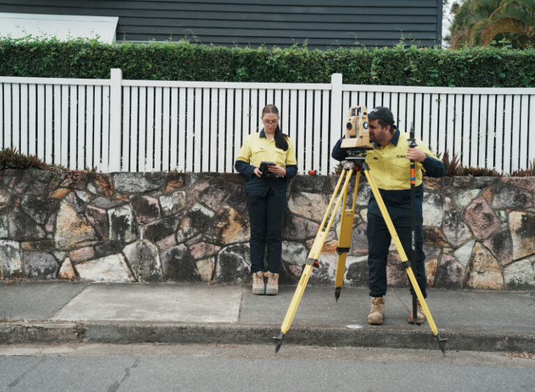
Our surveyors visit your property to locate and mark boundary corners, identify fencing, structures, and any encroachments using high-precision total stations and GNSS equipment.
This confirms where your boundaries lie and highlights any encroachments or issues that may affect your use or development of the land.
We reinstate lost or unclear boundaries where necessary and prepare a certified identification survey plan showing all relevant features.
This plan documents the current state of your land and can be used for legal, planning or construction purposes.
Once complete, we finalise the plan, issue a signed copy, and if required, lodge it with the Department of Natural Resources and Mines.
This provides peace of mind and a trusted reference for any future land dealings or approvals.
We start by reviewing your property’s information including, registered plans and council mapping to understand the legal boundaries and any easements or constraints.
This gives us a clear foundation to accurately interpret and locate the site boundaries.
Contact us for a quoteOur surveyors visit your property to locate and mark boundary corners, identify fencing, structures, and any encroachments using high-precision total stations and GNSS equipment.
This confirms where your boundaries lie and highlights any encroachments or issues that may affect your use or development of the land.
Contact us for a quoteWe reinstate lost or unclear boundaries where necessary and prepare a certified identification survey plan showing all relevant features.
This plan documents the current state of your land and can be used for legal, planning or construction purposes.
Contact us for a quoteOnce complete, we finalise the plan, issue a signed copy, and if required, lodge it with the Department of Natural Resources and Mines.
This provides peace of mind and a trusted reference for any future land dealings or approvals.
Contact us for a quoteWe take the stress out of understanding your site boundaries. Our process combines legal title research, field expertise and certified reporting to give you peace of mind and practical outcomes you can rely on.

We start with a title and plan review to understand the registered property dimensions and any easements or constraints.

Our surveyors locate, verify, and (where necessary) mark physical boundary points using best practice methods and precise equipment.

We assess for fencing discrepancies, encroachments or access issues that could affect future works or development.

We deliver a signed, compliant identification survey plan ready for legal, council or construction use.
Yes. In Queensland, they refer to the same type of survey. Both involve identifying, verifying and marking legal property boundaries, as well as documenting site conditions, improvements and any encroachments in relation to the title.
Yes, we can mark physical boundary corners on the ground where required. This is particularly helpful for fencing, building, or clarifying property lines.
It’s highly recommended. It confirms the legal extent of the land, identifies potential boundary disputes or encroachments, and helps you purchase with confidence.
Very. Our surveys are completed by registered cadastral surveyors using high-precision equipment and are certified in accordance with Queensland regulations.
Yes. In Queensland, every identification (boundary) survey must be lodged with the Department of Natural Resources and Mines.
We handle this process for you, ensuring your plan becomes a certified legal record. Once lodged, it’s available for access through the Department’s public records.

Feel free to give us a call, send us an email, or provide us with your details in the quote form here to organise an easy consultation for your project.
Or leave your message below and we’ll get in touch soon.